Airmate
Airmate is a free and easy to
- 类型:导航
- 评分:5.00
- 年龄要求:4+
- 内购:免费
- 语言: "EN", "FR", "DE", "IT", "PT", "RU", "ES"
- 星级:
- 上传者:Myriel Aviation SA
- 更新时间:2024-03-08 09:45:32
Airmate is a free and easy to
Airmate is a free and easy to use Electronic Flight Bag for pilots, providing help for flight planning and navigation, and including many social sharing features.
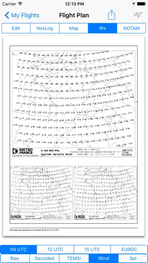
Thanks to Airmate EFB flight planning tools, you will get instant access to airport data and aviation maps worldwide, up to date weather and NOTAMs, and you could even file a flight plan.
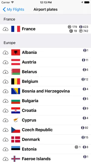
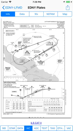
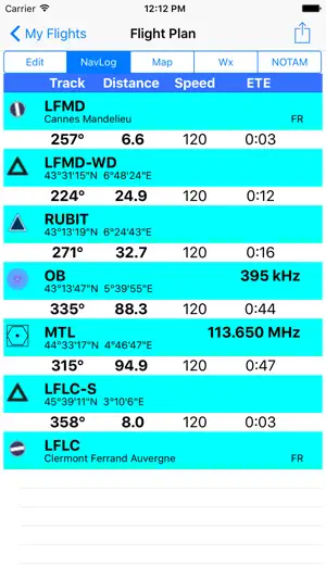
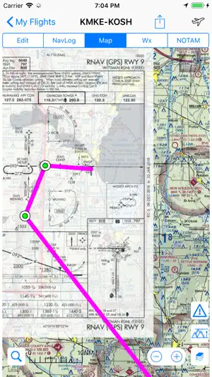
IFR and VFR airport diagrams and plates are freely available in US (FAA charts), all Europe, and more than 200 other countries. Most of them are georeferenced and could be overlaid on the aviation chart. A powerful Plate Manager allows to download in advance all airport plates in a country, they could be easily printed and viewed.
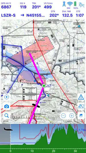
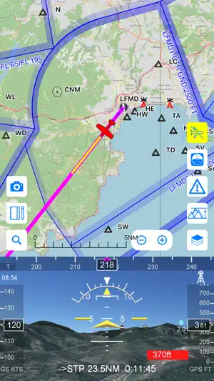
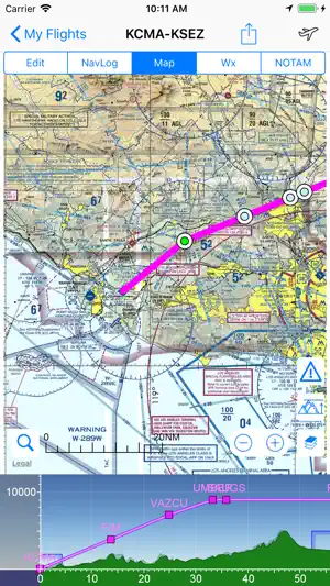
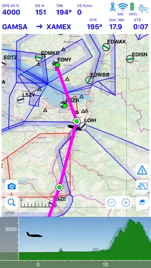
During the flight, the moving map will display the aircraft location along the route, show airports and aeronautical data details, warn you if your planned route is crossing restricted areas. A profile view is available to display terrain elevation, crossed areas and forecasted weather across the route. Airmate can also display a backup aircraft attitude indicator and flight parameters in an EFIS-like view using the device internal sensors or a supported external AHRS-capable ADS-B receiver or supported aircraft avionics. In the whole world, Synthetic Vision displaying in the EFIS-like view the ups and downs of rolling terrain ahead is available.
Airmate includes a worldwide aeronautical database updated free of charge with airports, navigation beacons, waypoints, airways, obstacles, regulated and restricted areas. Topographic maps and elevation data for most countries may be downloaded free of charge, as well as additional aviation map overlays such US Sectionals. A procedure database provide details of departure (SID), arrival (STAR) and instrument approaches in specific countries, and you could add those procedures to your planned flight route (the procedure database includes all US airports, and many RNP approaches in other countries). Once loaded, the procedure path is displayed on the aeronautical map, including curved paths and racetracks.
When coupled with a supported external ADS-B received, Airmate will display nearby traffic on the moving map, and receive FIS-B weather and NOTAM during the flight. To improve safety, Airmate can display neighbouring traffic received over mobile network. Such traffic include commercial airlines and transponder-equiped aircrafts, FLARM gliders, aircrafts whose pilots are using Airmate and other users using other safety broadcasting equipment.
Airmate is able to transmit the flight plan data to and receive flight parameters and AHRS data from supported avionics such Dynon SkyView.
Thanks to the Auto Route feature, you could search and select the best route for your flight, and then file your flight plan anywhere in the world.
Airmate will also record your flights and allow to replay them later or export the flight path in gpx format. Pilot log entries are automatically computed from flown flights.
A Satellite map display mode in flight planning or replay mode allows to familiarize with significant landmarks.
Airmate will save planned and flown flights, user waypoints and user aircrafts in the cloud and sync them between your devices and Airmate web flight planning.
Airmate brings numerous social features to the community. Pilots may leave ratings, tips and comments to share their experience with fellow pilots, and report fuel prices and landing fees. They could find friends, instructors, flight schools, aviation events and aircraft to rent near their home airport or any visited airport.
Airmate may be connected to most flight simulators to keep flying skills sharp. Planned flights and personal waypoints may be imported and exported, including from/to flight simulators.
Continued use of GPS running in the background can dramatically decrease battery life.
Terms of Use:
版本更新内容:
- added Data Manager functionality to download aeronautical data and program USB drive for Dynon SkyView Airmate database subscribers.
- Airmate may now be launched from Safari browser or external applications by calling an URL of the form airmate:/

旅游 免费
 查看
查看
 查看
查看

旅游 免费

天气 免费
CopyRight 2019 http://www.dxsdfy.com All Rights Reserved Sitemap
独秀网温馨提示:抵制不良游戏,拒绝盗版游戏,注意自我保护,谨防受骗上当,适度游戏益脑,沉迷游戏伤身,合理安排时间,享受健康生活!